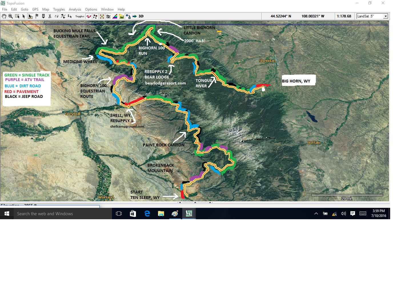
The 4th annual Big Horn Trail Race is 275 miles and 35,000 feet of climbing on mountain single track, running from Buffalo, Wyoming to Big Horn, Wyoming.
Due to Wyoming Covid regulations, registration will be capped at a maximum of 50 (subject to change).
EXPERT RIDERS ONLY!
START DATE: SEPTEMBER 4, 2020 7:00 a.m.

There are a lot of steep climbs on this route, EASY GEARS HIGHLY RECOMMENDED!
A front derailleur or a 28 or even 26 x 50 works well.
This route is almost a complete loop, the finish line is 30 miles on the road from the start line.
Start: Friday September 4, 2020 7 a.m. Leave from City Park, Buffalo WY.
2020 .gpx is here: https://ridewithgps.com/trips/52238734
SPOT Registration is here: will be up a few weeks before start.
If you need to rent a SPOT, let us know by August 20.
Our Facebook page is here: https://www.facebook.com/Big-Horn-Trail-Race-154576138552908/
COURSE RECORDS:
2019 Several starters, but no finishers
2018 Austin Sullivan 2 days, 16 hours, 20 minutes
Sarah Wallick 3 days 3 hours (smell the flowers category) *
2017 Aaron Denberg 2 days 18 hours (easier course)
* Any rider who stops ten or more hours per day (rides 14 or less) will be automatically entered in the "smell the flowers" category. This category recognizes that sleep deprivation affects some more than others.
The Bighorn Race is an unofficial challenge in the Big Horn mountains of northern Wyoming. The fourth running has a proposed start date of September 4, 2020. It is approximately 275 miles and has about 35,000 feet of climbing. The riding surface is probably most similar to the Colorado Trail Race, with lots of rocks and roots, but the Big Horn Mountains are geologically distinct from the Rocky Mountains with their own unique spin on the different life zones.
This event is not sanctioned or organized in any way. There are no permits, prizes or entry fees. It is a group of people riding their bikes on the same route at the same time. It is an entirely self-supported race against the clock. No drafting, blocking or other teamwork, no support and no caching allowed.
All that is provided is a suggested start time, a route and tabulation of results. There is no race organization, no checkpoints, no support system, nothing. If you choose to ride this course, you are doing so at your own risk. Like most routes in the mountains, this is a dangerous and potentially deadly course. There are several creek crossings which are normally low, but if there has been rain and the water is high, DO NOT RISK CROSSING, take the best way around. Other risks include rain, snow, bears, mountain lions, moose, lightning, , sleep deprivation and other risks too numerous to mention. You should ride this course with a partner or be very skilled in the backcountry. You should have first aid knowledge, the ability to self-rescue and carry a map and compass and know how to use them.
Bikepacking is an inherently dangerous sport and the only thing between you and serious injury or death is your own good judgment.
A video of some of the route is here: https://www.youtube.com/watch?v=m4KvxWsbSKo
Resupply water: The Big Horns have a surprising amount of water and it is usually difficult to travel more than 5 or 10 miles without finding some. However, there is one dry, and potentially very hot climb. Leaving Shell, at 135 miles, it is about 35 miles and 6,000 feet of climbing (on a steep but reasonable atv trail) to the next water.
--------------------------------------------------------------------------------------------------------------------------
A video of some of the route is here: https://www.youtube.com/watch?v=m4KvxWsbSKo
Resupply food:
60 miles -- Meadowlark Lodge https://www.lodgesofthebighorns.com/meadowlark-lake-lodge-wyoming.php This is LIMITED RESUPPLY. They offer a small selection of hot meals, candy bars and potato chips. That is about it. A good strategy is to bring additional food from the start and only supplement here.
60 miles -- Meadowlark Lodge https://www.lodgesofthebighorns.com/meadowlark-lake-lodge-wyoming.php This is LIMITED RESUPPLY. They offer a small selection of hot meals, candy bars and potato chips. That is about it. A good strategy is to bring additional food from the start and only supplement here.
135 miles --Shell store https://oldshellstore.com/
Limited but adequate resupply. Hours vary.
225 miles -- Bear Lodge http://bearlodgeresort.com/
Limited but adequate resupply. Hours vary.
229 miles -- Arrowhead Lodge https://www.arrowheadlodgewyoming.com/
Limited but adequate resupply. Hours vary.
Also, Elk View Lodge is one mile off route from Bear Lodge http://www.elkviewinn.com/ Limited but adequate resupply. Hours vary.
Limited but adequate resupply. Hours vary.
225 miles -- Bear Lodge http://bearlodgeresort.com/
Limited but adequate resupply. Hours vary.
229 miles -- Arrowhead Lodge https://www.arrowheadlodgewyoming.com/
Limited but adequate resupply. Hours vary.
Also, Elk View Lodge is one mile off route from Bear Lodge http://www.elkviewinn.com/ Limited but adequate resupply. Hours vary.
Resupply water: The Big Horns have a surprising amount of water and it is usually difficult to travel more than 5 or 10 miles without finding some. However, there is one dry, and potentially very hot climb. Leaving Shell, at 135 miles, it is about 35 miles and 6,000 feet of climbing (on a steep but reasonable atv trail) to the next water.
Make sure you have a rear blinky light in case you are on a road at night!
You will probably encounter horseback riders at some point, they do a lot of trail maintenance work. Many of these horses will have never seen mountain bikers before and can easily spook. Please be good bikepacking ambassadors when you see horses and immediately call out, "Hey, how's it going?," dismount your bike and exit the trail to the downhill side.
You will probably encounter horseback riders at some point, they do a lot of trail maintenance work. Many of these horses will have never seen mountain bikers before and can easily spook. Please be good bikepacking ambassadors when you see horses and immediately call out, "Hey, how's it going?," dismount your bike and exit the trail to the downhill side.
Additional Resources:
Highly recommended is Avenza maps app: http://www.avenza.com/pdf-maps/store You can open the track on your phone with this app and this app will also geolocate you on the USFS map of the area, even without cell service.
You need both halves of the Big Horn National Forest, they are $4.99 each: https://www.avenzamaps.com/maps/83071/bighorn-national-forest-visitor-map-north-half-2016/
Or, if you don’t want to buy these maps, there is a free road map which will at least tell you where you are in relation to the nearest road: https://www.avenzamaps.com/maps/75096/bighorn-national-forest-mvum/
--------------------------------------------------------------------------------------------------------------------------
To be included in the list of finishers, you must follow the same rules of self-supported travel as those for the Arizona Trail Race and the Colorado Trail Race:
SPOT Tracking
The race will be tracked by Trackleaders, providing a live map, elevation profile and other stats that can be used to follow along. Carrying a SPOT and being tracked by Trackleaders is not mandatory but encouraged.


